The website construction kit for public transport
The website is your companys flagship. Your customers can use it to plan trips and buy tickets or travelcards. Public authorities can find out about your activities and the quality of your services. Local residents, the media and politicians can find out all about your company, construction projects and expansion plans here.
From our many years of experience, we know the needs of transport companies and that for public transport companies, all information revolves around stops and lines as well as the connections that run on them or - in the event of construction projects and disruptions - are impaired. We offer a modular kit so that you can use this information on your website in the best possible way and tailored to your requirements. All tools can be used individually or in combination for a complete user journey. With mobilityCMS you get connections to web services and official public transport data hubs, from which a lot of information is automatically kept up to date. Time-consuming manual adjustments are therefore no longer necessary.
Of course, you have every opportunity to implement your individual layout and design in terms of white label components. And specific requirements that we have not yet provided for can be programmed individually, as with any CMS. You decide whether we program your website or whether you continue to work with your existing web agency. In this case, the agency takes over the design and programming of the website. We work in partnership with them and offer advice, technical support or the development of extensions as required.
The CMS
mobilityCMS includes extensions of commercially available, established content management systems as they are relevant for public transport. It has a modular structure, whereby you can use all modules or just individual ones, depending on your needs. We currently offer two versions. One offers extensions for the widely used TYPO3. A technically more modern variant is based on add-ons for the headless CMS Statamic. Both variants are open-source software. This means that there are no license costs for you.
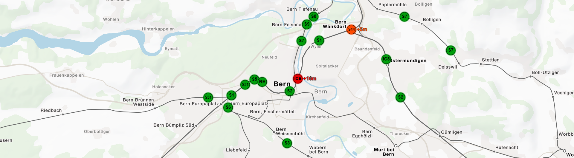
Attractive public transport maps
In mobilityCMS, maps are the basis for displaying information in many places. They serve as an overview of the route network and stops, show the course of routes, the location of disruptions or the position of destinations of tourist interests. The maps focus on public transport and show, for example, stop edges and station buildings particularly prominently. The color scheme of the maps can be adapted to your corporate design.
Connection search
There are many options available for the connection search. Regardless of the tool you choose, you can use mobilityCMS to display all connections clearly as a string of pearls or on the map.
Network plans
We calculate network plans largely automatically from timetables and graphically optimize them manually as required. The advantage of this is that the plans can be updated at any time without any additional work. The network maps are the basis for visualizing current information such as the routes of lines or disruptions in the network in interactive form. Of course, the maps are also suitable for output in printed form.
Stops
Stops are automatically synchronized from different data sources such as Delfi in Germany or Atlas (formerly DiDok) in Switzerland. Regardless of the source, you can always display the latest data on your website. The CMS then offers the option of adding additional information such as texts or images for individual stops.
Station maps
If you want to offer detailed situation maps for your stops, mapset provides an intuitive drawing tool that you can use to illustrate the specific situation at a stop. This is interesting for regular operations, but also important in the case of special events, constructions or when operating replacement services.
Faults and construction sites
Manage disruptions as well as planned construction sites with our tool MOCO. In MOCO all events can be recorded individually and mapped to routes or stops. By connecting various sources to MOCO disruptions can also be read in automatically and displayed on an overview map.
Tourist highlights
For many companies, tourism is an important segment. It makes sense for these companies to display the tourist highlights that can be reached with their offer on a map. mobilityCMS provides the necessary components for this. Map displays, lists and detailed descriptions can be easily implemented.
Any other pages
As with any other CMS, additional pages such as company information or a news page can be added as required. The advantage of mobilityCMS in this context is the possibility to integrate map views on such pages as well. For example, if you write a post about one of your lines, you can integrate a map showing the course of this line.